
November 1, 1976, Appleton Post-Crescent
The timeframe of this story predates a post we did last year showing a 1924 "auto trails" map published by Rand McNally: http://menashabook.blogspot.com/2015/03/autotrails-map-of-1924.html. As we discussed then, early efforts to help drivers navigate what roads there were, were limited to following landmarks and crude signage. At least by 1924, there were some standards being developed. This story, which is based in 1916, comes 8 years before the 1924 map, and was essentially describing a guidebook that gave sequential, left turn, right turn directions...a very crude GPS if you will! Taking a long trip in an automobile must have been quite the adventure.
I have a 1915 King’s Official Route Guide and a 1918 Automobile Blue Book. King’s is a little more detailed than the Blue Book and the AAA book in the article. I will relay the Menasha portion of the routes from Oshkosh to Menasha and Menasha to Appleton from King’s:
ReplyDeleteOshkosh to Menasha, 15.1 miles.
Road good, gravel and cinders most of the way.
[Fast forward to Neenah.]
13.8 Neenah (Note- Hotel accommodations not the best; go to Appleton.) [The hotel failed to advertise in the book.] Continue straight ahead.
13.8 Cross canal bridge. (C. H. Bergstrom’s garage on left.)
13.9 Cross canal bridge.
14.0 Cross river bridge; follow trolley on Washington St., passing Menasha and Neenah depot on left.
14.3 Cross R. R.
14.4 Pass armory on left and school on right.
14.5 Cross R. R.
14.6 Cross bridge over river.
14.7 Cross bridge over river; enter on Tayco St.
14.8 Turn right with trolley to Main St. to
15.0 Menasha Motor Car Co. on left.
Menasha to Appleton, 5.6 miles.
Road good, all gravel.
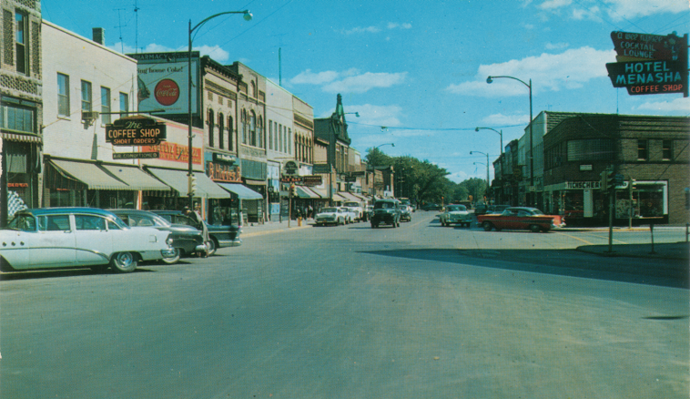
.0 Leave Hotel Menasha, go north on Main St., following trolley.
.1 Turn left with trolley on Racine St.
.3 Turn right with trolley on 3rd St., just before crossing trolley.
.6 Turn left on De Pere St.
.7 Cross two R. R.s.
.8 Pass Polish Catholic church on left and take next
.9 Turn right, and follow angling road to end of road. [Appleton Rd.]
2.3 Curve left.
2.6 Pass schoolhouse on left.
3.2 Curve right and continue to end of road. [Midway Rd.]
4.3 Turn left, picking up trolley. [Oneida St.]
4.6 Pass St. Elizabeth’s hospital on right…